GEOG 1800 - Geospatial Technology
Earthquake Hazard along the Wasatch Front
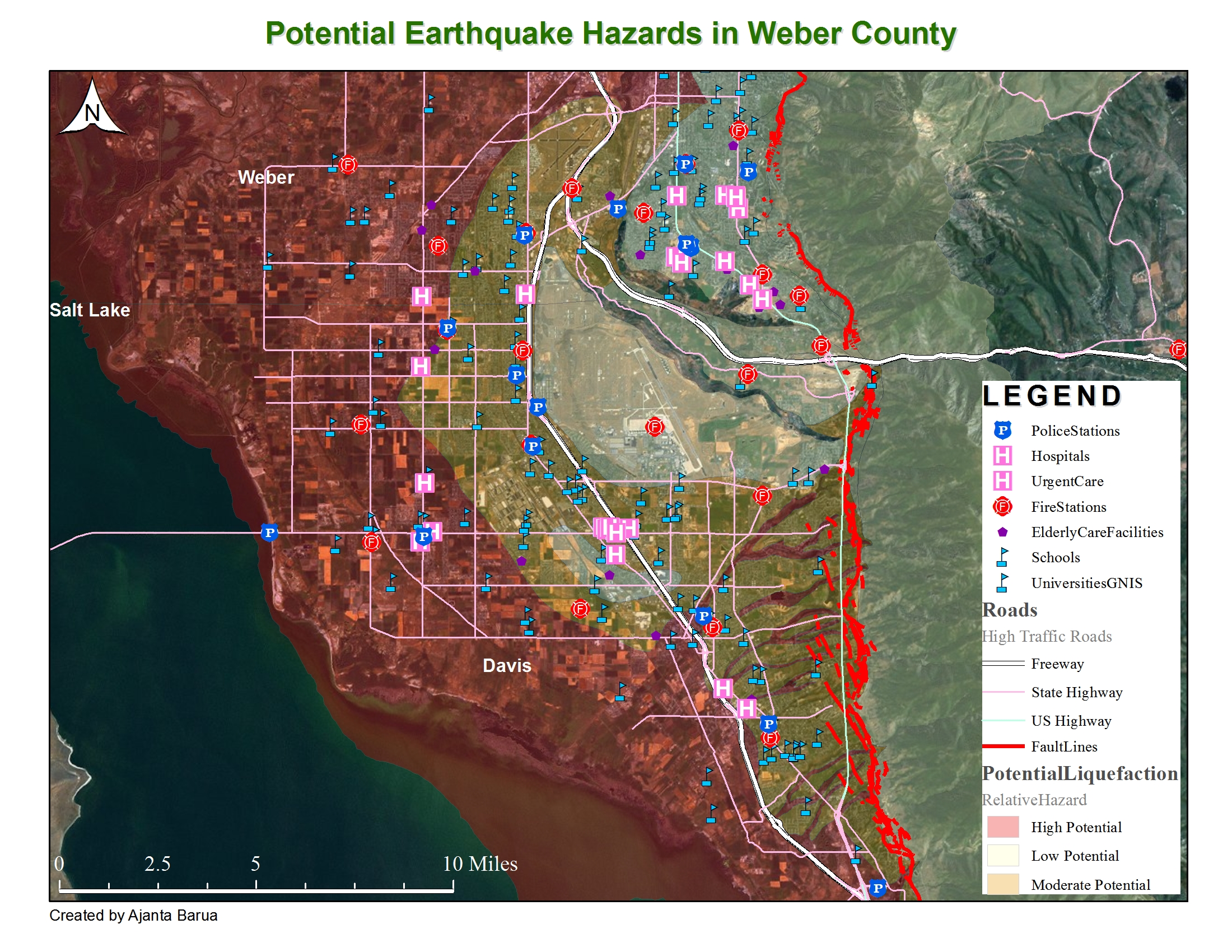
For my Geography 1800: Geospatial Information Systems class, we had to do a case study where we examine fault lines, potential liquefaction, and locations of where police stations, hospitals and fire departments are located. We had to chose a county in Utah of our choice, where I chose to do Weber County. I chose Weber County because I've seen most students doing Salt Lake county and I spend a lot of time in Weber County since I work in downtown Ogden. |
Case Study Questions
- Question 1: What potential problems do you see in
terms of the spatial distribution of hospitals, police stations, and fire
stations in * County, Utah compared to the fault lines and potential
liquefaction zones? How about transportation
networks? How would that affect
emergency response crews?
I can see that Hospitals are spread throughout the Weber county pretty well but a lot of hospitals are near the fault lines and half of them are in high potential liquefaction zones. Police and fire stations are spread out pretty well too and most are in moderate potential liquefaction zones so aren't as bad as the hospital layout. I added a roads layer to see where the major freeways and highways are because that's where most people will be on and it seems like part of the freeway is in high potential liquefaction zones but in the main city, it seems safer. The people who are on freeways might get cut off at the edge of Davis County which will cause problems since it's hard to exit from the freeway on the lower portion on the map. Looking at the potential liquefaction zones, you can see that if an earthquake would occur, we might be trapped in Weber County. High potential liquefaction zones surround the county, the only way out is north, south, or east, where going north or south might pose a problem, going east is out the question since it leads into a canyon and the one freeway that leads out in that direction might be destroyed since it lies right on top of the fault line.
- Questions 2: How close (in miles) do you live, work, or go to school near a fault line and what liquefaction zone are you in? What potential hazards might you expect during or following an earthquake along the Wasatch Front. Include personal pictures of your area of interest for your ePortfolio write-up.
I actually live in West Valley, in Salt Lake County but work in Ogden, which is in Weber County. I work about 2.5 miles away from a faultline and work in a high potential liquefaction zone. I work near a freeway entrance and if I had a choice to hurry and evacuate, I would chose to go south to Salt Lake since it's a shorter distance on a high potential liquefaction zone than going north. If you go north, you'll be driving on high potential liquefaction zones for a bit more than 40 minutes or so but if you go south, you'll be driving on it for about 25 minutes or so. If you go south though, you'll be much closer to the lake than going north...so it's a hard decision. And if I go north, I can go see my family that lives up north and if I go south, I can go home. I'd probably end up going home since I should go protect my personal information and stuff.
Analysis
Since I found out that if I was at work, I might get trapped inside of the city because freeways would be packed on both ends, I don't know what to do. It's also hard to know what to do in an earthquake situation because it would be so sudden, it's hard to act as rational as you should. I work on the fourth floor of my building, so I would help that the earthquake is not strong enough to destroy the building since there's 2 floors above me and 3 floors and a basement underneath me. I would hope not to get sandwiched. There's not really a way to change the layout of hospitals and police or fire stations since the city is already fully developed. It would be hard to change anything with the layout and it's hard to change or build other freeways since going south, there's not room between the lake and the mountain. If you go north, you don't have the take the freeway but you can take a highway which is right next to the mountain right next to a fault line. I can't think of any actions that the city or people can take except for hope for the best.
*Even though I did some cartographic design, I obtained all of the data elsewhere. The imagery was provided by ESRI. The layers were obtained from the gdb93.agrc.utsh.gov database server.